Home > Blog, Conspiracy, Pictures > Area 51

Area 51

January 19th, 2006 Leave a comment Go to comments

So we were on Google Maps looking at Area 51. The actual map is blotted out, mainly because they have no public maps of the military base but I’m assuming the US Gov has a block on the location. Take a look.

Area 51 Map Mode

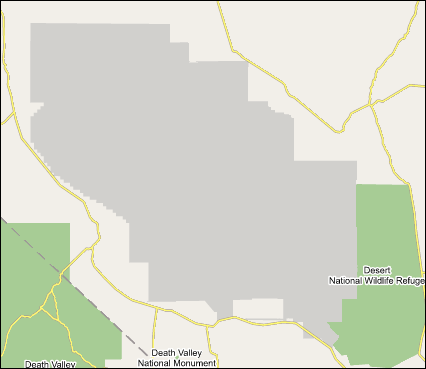
When we took a peak at it in satellite mode we see an aerial shot of the base.

Area 51 Aerial Shot

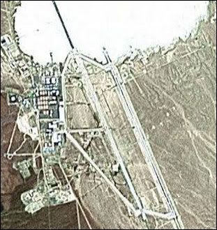
So… is that snow in the middle of the desert?

Categories: Blog, Conspiracy, Pictures Tags:
  1. TheConspiracyTeam
    January 20th, 2006 at 00:01 | #1

    Technically speaking, a ‘desert’ is a place with small amounts of rainfall per year (e.g. Sahara, Antartica, etc.). Since Antartica has the same “white blotted out appearance” there are three possibilities:
    (1) Area 51 is being blocked out from prying eyes of those other than the Elites in the US government.
    (2) Someone spilled a lot of white paint and didn’t do a very good clean up job
    Or (3) The US has produced a secret weapon that is able to take HOT deserts (eg. Sahara) and turn them into COLD deserts (eg. Antartica)
    The reasons for (3) are unknown… but I believe it is part of an intricit scheme where Penguins will indeed March… and take over the rest of the world.
    I mean its obviously not a bunch of paint spilled all over the place…
    And why would the US gov’t want to hide anything from the rest of the world?

  2. January 20th, 2006 at 00:06 | #2

    A plan to freeze the terrorists? It’s all so clear now.

  3. January 20th, 2006 at 18:35 | #3

    old news

  4. January 20th, 2006 at 18:37 | #4

    Old news that the Americans have a weather machine…?

  1. No trackbacks yet.

css.php